Flood of 2008
I’ve been getting a lot of calls/emails/IMs from family and friends about how the floods are effecting me in the Cedar Rapids area, so here’s some info in case anyone checks here first.
My place in Marion is fine, we’re far enough from the Cedar River that we’re not affected by its rise to +31 feet. Unfortunately, some of my friends in Palo, IA and possibly more near Downtown Cedar rapids are, given that over 1,000 blocks were under water on Friday (check out the map in This article). On Thursday, heavy rain in the morning caused some flash flooding that came within a few hundred feet of my place, however I’m high enough that it was not an issue. Pictures will be posted soon of the flooding in Marion on June 12, 2008.
As it seems like we have too much water, the opposite is also true. Having lost close to 3/4 of its capacity (now back up to 50% according to This report from KCRG news), Everyone has been asked to limit water use to drinking; no laundry, flushing toilets, showers, washing hands… I live in Marion which has a different water system, however they have now connected the Marion system to the Cedar Rapids system to try to maintain pressure (Advisory from City of Marion). We’ll see how this plays out in the next few days.
Here are some pictures that I’ve taken during the last few days. Iowa flood of 2008.
Below is a comparison of how high the waters were on Friday, June 13, 2008. The “Non-Flood” picture was taken sometime after 1985.

(image courtesy of http://www.jithy.com/favorite.htm)
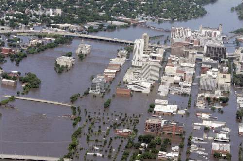
(image courtesy of www.gazetteonline.com)